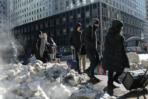
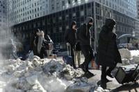
After more than a foot (30 centimeters) of snow fell over parts of New York during this past weekend's historic winter storm, the city is working to melt away the remains before the next blizzard strikes.
Though the storm has passed, temperatures remain below freezing, impeding natural snowmelt, with no relief in sight for the forecast.
The snow has been shoveled to the side, but it remains hazardous for both pedestrians and drivers, and needs an extra boost to go away in a timely fashion.
"The problem there is that if we don't melt it, then it'll sit there for a while," said Javier Lojan, who oversees New York's sanitation department, at a Wednesday press conference.
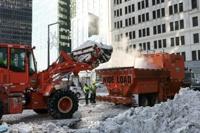
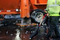
Their secret weapon? Giant snow "hot tubs" capable of melting between 60 and 120 tons of snow an hour.
Trucks filled with excavated snow dump their trailers into the machines, filled with water, to rapidly melt it. Although the ensuing steam gives the machines a jacuzzi-like appearance, the water inside is heated only to 38F (3C).
The water is then filtered and dumped into storm drains.
More than 2,500 city workers are mobilized for the 24/7 operation.
"Our priority right now is to get the bus roads open, because we want to make sure that people can get on and off the buses and get to work or school as needed," Lojan said.
The snow melters, which are used at other cities and airports across North America, have not been used at such a high scale in New York since 2021.
Keep it Clean. Please avoid obscene, vulgar, lewd,
racist or sexually-oriented language. PLEASE TURN OFF YOUR CAPS LOCK. Don't Threaten. Threats of harming another
person will not be tolerated. Be Truthful. Don't knowingly lie about anyone
or anything. Be Nice. No racism, sexism or any sort of -ism
that is degrading to another person. Be Proactive. Use the 'Report' link on
each comment to let us know of abusive posts. Share with Us. We'd love to hear eyewitness
accounts, the history behind an article.
...EXTREME COLD WARNING IN EFFECT FROM MIDNIGHT FRIDAY NIGHT TO NOON
CST SATURDAY...
...EXTREME COLD WATCH REMAINS IN EFFECT FROM SATURDAY AFTERNOON
THROUGH SUNDAY MORNING...

* WHAT...For the Extreme Cold Warning, dangerously cold wind chills
ranging from just below zero to single digits above zero are
expected. For the Extreme Cold Watch, dangerously cold wind chills
as low as 2 above possible.

* WHERE...Autauga, Bibb, Blount, Chilton, Dallas, Etowah, Fayette,
Greene, Hale, Jefferson, Lowndes, Marengo, Perry, Pickens, Shelby,
St. Clair, Sumter, Tuscaloosa, Walker, and Winston Counties.

* WHEN...For the Extreme Cold Warning, from midnight Friday Night to
noon CST Saturday. For the Extreme Cold Watch, from Saturday
afternoon through Sunday morning.

* IMPACTS...Frostbite and hypothermia will occur if unprotected skin
is exposed to these temperatures. An extended period of
subfreezing temperatures could cause pipes to burst.

PRECAUTIONARY/PREPAREDNESS ACTIONS...

Dress in layers including a hat, face mask, and gloves if you must
go outside.

Keep pets indoors as much as possible.

Make frequent checks on older family, friends, and neighbors. Ensure
portable heaters are used correctly. Do not use generators or grills
inside.

To prevent freezing and possible bursting of pipes they should be
wrapped, drained, or allowed to drip slowly.

If you do not have heat in your home or lack shelter, you can call
211 or visit 211connectsalabama.org for assistance locating
appropriate shelter from the cold.

&&
Currently in Selma
31°
Mostly Cloudy
55° / 23°
3 AM
31°
4 AM
30°
5 AM
30°
6 AM
29°
7 AM
28°
Get Black Belt News headlines for free in your inbox every day!
Success! An email has been sent to with a link to confirm list signup.
Error! There was an error processing your request.


(0) comments
Welcome to the discussion.
Log In
Keep it Clean. Please avoid obscene, vulgar, lewd, racist or sexually-oriented language.
PLEASE TURN OFF YOUR CAPS LOCK.
Don't Threaten. Threats of harming another person will not be tolerated.
Be Truthful. Don't knowingly lie about anyone or anything.
Be Nice. No racism, sexism or any sort of -ism that is degrading to another person.
Be Proactive. Use the 'Report' link on each comment to let us know of abusive posts.
Share with Us. We'd love to hear eyewitness accounts, the history behind an article.