Portugal Golden Visa: Approvals down, family permits up in 2024
Portugal's Golden Visa (ARI) program issued fewer residence permits in 2024 than the previous year, but family reunification permits linked to the program nearly doubled. The shift, documented in Portugal's latest official migration reporting, marks a notable change in the program's profile after years of policy revisions. Movingto analyzed the latest official migration data to track these changes.
The numbers
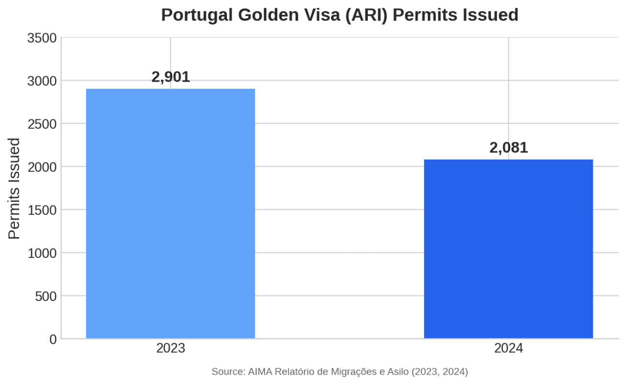
In 2024, Portugal issued 2,081 ARI residence permits, down from 2,901 in 2023—a 28% decline year over year, according to the Agency for Integration, Migration and Asylum (AIMA)'s annual migration and asylum report.
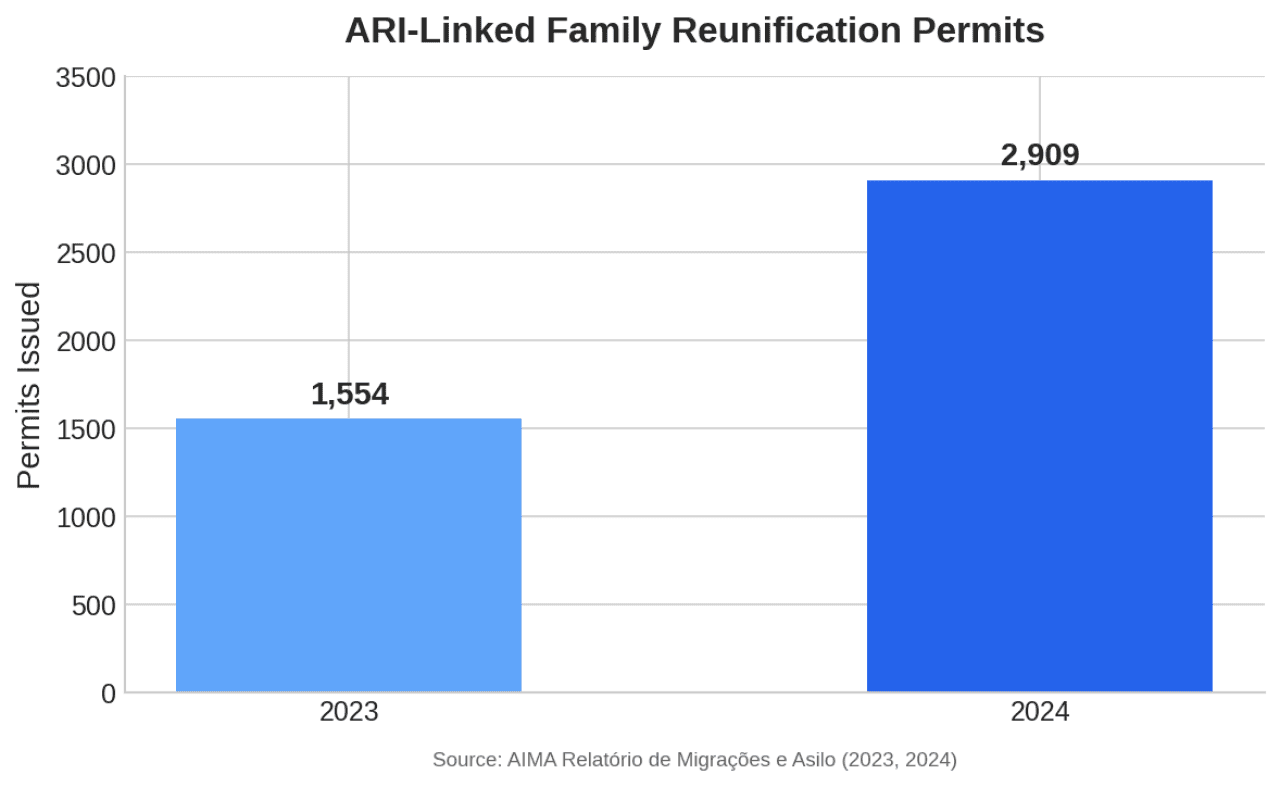
At the same time, family reunification permits linked to ARI rose to 2,909 in 2024, up from 1,554 in 2023—an 87% increase.
Moveto
Moveto
Who's applying?
The most recent nationality breakdown, published for 2023, shows the United States led with 567 permits, followed by China with 306.
The Golden Visa—formally the Autorização de Residência para Atividade de Investimento (ARI)—launched in October 2012. Official reporting from the program's first decade shows:
More than €7.3 billion in total investment (October 2012–October 2023)
Over 12,700 main applicants
More than 33,000 total beneficiaries, including family members
Real estate routes accounting for roughly 88%–90% of historical investment
The 2022 annual reporting (RIFA 2022) provides a granular snapshot: €654.3 million in total ARI investment that year, with property purchases representing €534.6 million across 1,008 investments.
What may explain the shift?
The program has undergone significant changes in recent years, including restrictions on real estate investment routes and the administrative transition from Serviço de Estrangeiros e Fronteiras (SEF) to AIMA. These changes created a complex operating environment that can influence year-to-year totals.
The data doesn't explain causation, but it shows a clear pattern: fewer new ARI permits, more family reunification.
Methodology
This story summarizes publicly available reporting from Portuguese migration authorities. Year-over-year comparisons are calculated from reported annual totals. Figures may be revised by the source agency in later publications.
Keep it Clean. Please avoid obscene, vulgar, lewd,
racist or sexually-oriented language. PLEASE TURN OFF YOUR CAPS LOCK. Don't Threaten. Threats of harming another
person will not be tolerated. Be Truthful. Don't knowingly lie about anyone
or anything. Be Nice. No racism, sexism or any sort of -ism
that is degrading to another person. Be Proactive. Use the 'Report' link on
each comment to let us know of abusive posts. Share with Us. We'd love to hear eyewitness
accounts, the history behind an article.
...EXTREME COLD WARNING NOW IN EFFECT FROM MIDNIGHT TONIGHT TO NOON
CST SUNDAY...
...WIND ADVISORY IN EFFECT FROM 2 AM TO 9 PM CST SATURDAY...


* WHAT...For the Extreme Cold Warning, dangerously cold wind chills
below zero are expected. For the Wind Advisory, northwest winds 15
to 25 mph with gusts up to 40 mph expected.

* WHERE...Autauga, Bibb, Blount, Chilton, Dallas, Etowah, Fayette,
Greene, Hale, Jefferson, Lamar, Lowndes, Marengo, Marion, Perry,
Pickens, Shelby, St. Clair, Sumter, Tuscaloosa, Walker, and
Winston Counties.

* WHEN...For the Extreme Cold Warning, from midnight tonight to noon
CST Sunday. For the Wind Advisory, from 2 AM to 9 PM CST Saturday.

* IMPACTS...Gusty winds will blow around unsecured objects. Trees
could be blown down and a few power outages may result. Frostbite
and hypothermia will occur if unprotected skin is exposed to these
temperatures. An extended period of subfreezing temperatures could
cause pipes to burst.

PRECAUTIONARY/PREPAREDNESS ACTIONS...

Winds this strong can make driving difficult, especially for high
profile vehicles. Use extra caution.

Secure outdoor objects.

Dress in layers including a hat, face mask, and gloves if you must
go outside.

Keep pets indoors as much as possible.

Make frequent checks on older family, friends, and neighbors. Ensure
portable heaters are used correctly. Do not use generators or grills
inside.

To prevent freezing and possible bursting of pipes they should be
wrapped, drained, or allowed to drip slowly.

&&
Currently in Selma
55°
Sunny
56° / 29°
4 PM
55°
5 PM
52°
6 PM
48°
7 PM
43°
8 PM
41°
Get Black Belt News headlines for free in your inbox every day!
Success! An email has been sent to with a link to confirm list signup.
Error! There was an error processing your request.


(0) comments
Welcome to the discussion.
Log In
Keep it Clean. Please avoid obscene, vulgar, lewd, racist or sexually-oriented language.
PLEASE TURN OFF YOUR CAPS LOCK.
Don't Threaten. Threats of harming another person will not be tolerated.
Be Truthful. Don't knowingly lie about anyone or anything.
Be Nice. No racism, sexism or any sort of -ism that is degrading to another person.
Be Proactive. Use the 'Report' link on each comment to let us know of abusive posts.
Share with Us. We'd love to hear eyewitness accounts, the history behind an article.