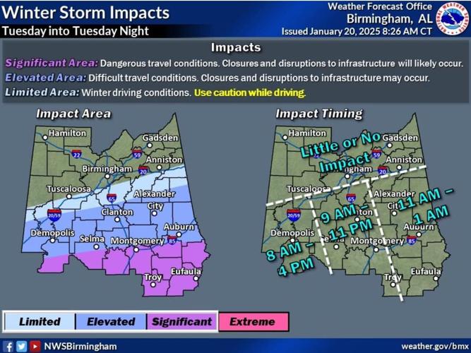
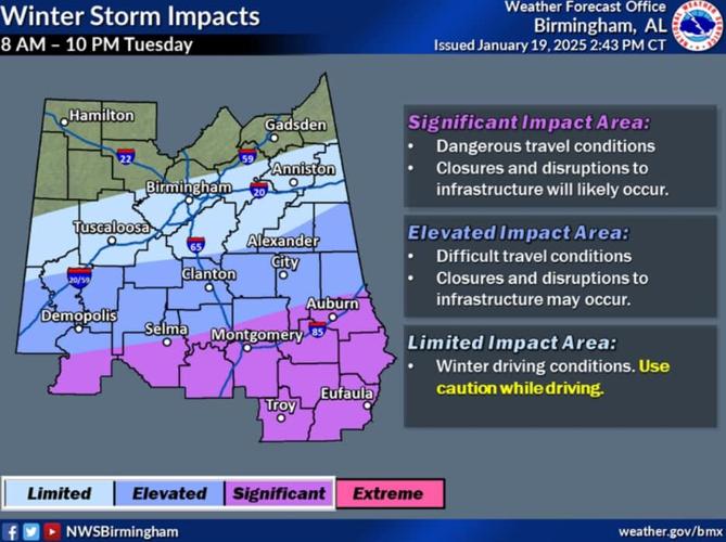

Much of the Black Belt is under a winter storm watch or warning from Monday through Wednesday as an arctic blast of cold temperatures and possible snow approach.
The winter storm warning started at 4:20 a.m. Monday and continues through Wednesday at 6 a.m., according to the National Weather Service. The warning is for Barbour, Bullock, Dallas, Lowndes, Macon, Marengo, Montgomery, Pike, and Russell counties.
A winter storm watch is in effect from the same timeframe for Autauga, Bibb, Chambers, Chilton, Coosa, Elmore, Greene, Hale, Lee, Perry, Randolph, Sumter, and Tallapoosa counties.
The National Weather Service says heavy mixed precipitation is possible with total snow and sleet accumulations between 1 and 3 inches and ice accumulations around a light glaze possible from Tuesday morning through late Tuesday night in portions of south central and southwest Alabama, northwest Florida, and southeast Mississippi.
See the Alabama Emergency Management report from Monday morning here.
Updated Jan. 20 at 10:50 a.m. The Black Belt News Network will continue to update this report as more winter advisories are issued.

(0) comments
Welcome to the discussion.
Log In
Keep it Clean. Please avoid obscene, vulgar, lewd, racist or sexually-oriented language.
PLEASE TURN OFF YOUR CAPS LOCK.
Don't Threaten. Threats of harming another person will not be tolerated.
Be Truthful. Don't knowingly lie about anyone or anything.
Be Nice. No racism, sexism or any sort of -ism that is degrading to another person.
Be Proactive. Use the 'Report' link on each comment to let us know of abusive posts.
Share with Us. We'd love to hear eyewitness accounts, the history behind an article.