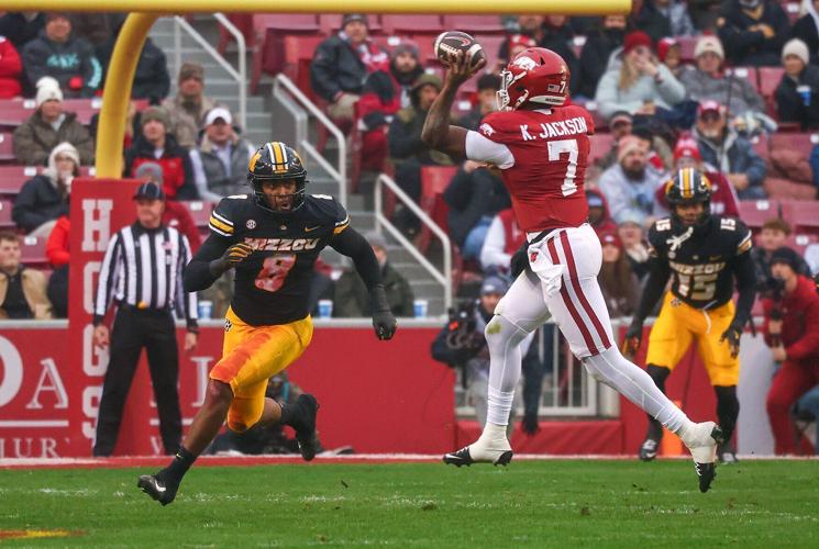
Mizzou’s Damon Wilson II (8) puts pressure on Arkansas quarterback KJ Jackson (7) during the first half Nov. 29 at Donald W. Reynolds Razorback Stadium in Fayetteville, Ark. Wilson left Mizzou with another gap to fill on defense when he transferred to Miami on Thursday.
Mizzou’s Damon Wilson II (8) puts pressure on Arkansas quarterback KJ Jackson (7) during the first half Nov. 29 at Donald W. Reynolds Razorback Stadium in Fayetteville, Ark. Wilson left Mizzou with another gap to fill on defense when he transferred to Miami on Thursday.
Former Missouri edge rusher Damon Wilson II announced his commitment to the Miami Hurricanes on Thursday.
Wilson transferred to Mizzou from Georgia ahead of the 2025 season and quickly emerged as one of the SEC’s most productive pass rushers. In 13 games, he totaled 23 tackles, 9½ tackles for loss and a team-high nine sacks while generating 54 quarterback pressures, according to Pro Football Focus.
The Venice, Florida, product spent two seasons at Georgia before breaking out in Missouri’s defense last season. He will return to the Sunshine State for his final season of eligibility after also considering LSU and Texas Tech.
Wilson’s departure leaves Missouri without both of its starting edge rushers from a season ago, as Zion Young is expected to be selected in the 2026 NFL Draft. The Tigers also lost reserve defensive ends Nate Johnson and Javion Hilson to the portal this offseason, part of a broader defensive transition that will see Missouri replace every starter from its 2025 unit.
Missouri has moved quickly to address the edge position, adding Louisville freshman CJ May along with transfers Jaden Jones and Cavan Tuley before the deadline for new portal entries. Holdovers Darris Smith and Langden Kitchen are also expected to factor into the rotation as Missouri reshapes its defensive front heading into 2026.
Keep it Clean. Please avoid obscene, vulgar, lewd,
racist or sexually-oriented language. PLEASE TURN OFF YOUR CAPS LOCK. Don't Threaten. Threats of harming another
person will not be tolerated. Be Truthful. Don't knowingly lie about anyone
or anything. Be Nice. No racism, sexism or any sort of -ism
that is degrading to another person. Be Proactive. Use the 'Report' link on
each comment to let us know of abusive posts. Share with Us. We'd love to hear eyewitness
accounts, the history behind an article.
...COLD WEATHER ADVISORY IN EFFECT FROM MIDNIGHT FRIDAY NIGHT TO
NOON CST SATURDAY...
...EXTREME COLD WATCH NOW IN EFFECT FROM SATURDAY AFTERNOON THROUGH
SUNDAY MORNING...

* WHAT...For the Cold Weather Advisory, very cold wind chills as low
as 1  expected in the north to 10 to 15 in the southeast. For the
Extreme Cold Watch, dangerously cold wind chills as low as 1 above
possible in the north to 5 to 10 in the southeast.

* WHERE...Autauga, Barbour, Bibb, Blount, Bullock, Calhoun,
Chambers, Cherokee, Chilton, Clay, Cleburne, Coosa, Dallas,
Elmore, Etowah, Fayette, Greene, Hale, Jefferson, Lee, Lowndes,
Macon, Marengo, Montgomery, Perry, Pickens, Pike, Randolph,
Russell, Shelby, St. Clair, Sumter, Talladega, Tallapoosa,
Tuscaloosa, Walker, and Winston Counties.

* WHEN...For the Cold Weather Advisory, from midnight Friday Night
to Saturday morning. For the Extreme Cold Watch, from Saturday
afternoon through Sunday morning.

* IMPACTS...Frostbite and hypothermia will occur if unprotected skin
is exposed to these temperatures. An extended period of
subfreezing temperatures could cause pipes to burst.

PRECAUTIONARY/PREPAREDNESS ACTIONS...

Dress in layers including a hat, face mask, and gloves if you must
go outside.

Keep pets indoors as much as possible.

Make frequent checks on older family, friends, and neighbors. Ensure
portable heaters are used correctly. Do not use generators or grills
inside.

If you do not have heat in your home or lack shelter, you can call
211 or visit 211connectsalabama.org for assistance locating
appropriate shelter from the cold.

To prevent freezing and possible bursting of pipes they should be
wrapped, drained, or allowed to drip slowly.

Use caution while traveling outside. Wear appropriate clothing, a
hat, and gloves.

&&
Currently in Selma
31°
Partly Cloudy
55° / 23°
10 PM
30°
11 PM
30°
12 AM
30°
1 AM
31°
2 AM
30°
Get Black Belt News headlines for free in your inbox every day!
Success! An email has been sent to with a link to confirm list signup.
Error! There was an error processing your request.


(0) comments
Welcome to the discussion.
Log In
Keep it Clean. Please avoid obscene, vulgar, lewd, racist or sexually-oriented language.
PLEASE TURN OFF YOUR CAPS LOCK.
Don't Threaten. Threats of harming another person will not be tolerated.
Be Truthful. Don't knowingly lie about anyone or anything.
Be Nice. No racism, sexism or any sort of -ism that is degrading to another person.
Be Proactive. Use the 'Report' link on each comment to let us know of abusive posts.
Share with Us. We'd love to hear eyewitness accounts, the history behind an article.