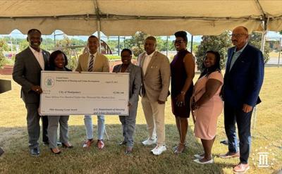

The City of Montgomery has received a PRO Housing Grant from the U.S. Department of Housing and Urban Development to be used in West Montgomery.
A press conference was held by Montgomery Mayor Steven Reed and other officials on Thursday in which it was announced that the funds will be used for "affordable housing options and accessibility" in the area.
West Montgomery is part of the Selma to Montgomery trail in which civil rights activists took to demand equal voting rights and an end to segregation.
"So we're thankful to stand here today as one of 21 communities across the country to receive funding from the Pathways to Removing Obstacles or pro housing program to improve West Montgomery along the National Historic Selma-Montgomery Trail," he said.
HUD Regional Administrator Jennifer Collins said that some of the ways to create more affordable housing was by changing outdated zoning and land use policies, changing "inefficient" procedures, and creating pathways in what she said was a gap to sources in development.
"The goal of Pathways of the pro housing program is to further develop, evaluate, and implement housing policy plans," she said. "Improve housing strategies and facilitate affordable housing, production and preservation."
The City of Montgomery received a $3,581,160 to implement the program.
See the full press conference here.
(0) comments
Welcome to the discussion.
Log In
Keep it Clean. Please avoid obscene, vulgar, lewd, racist or sexually-oriented language.
PLEASE TURN OFF YOUR CAPS LOCK.
Don't Threaten. Threats of harming another person will not be tolerated.
Be Truthful. Don't knowingly lie about anyone or anything.
Be Nice. No racism, sexism or any sort of -ism that is degrading to another person.
Be Proactive. Use the 'Report' link on each comment to let us know of abusive posts.
Share with Us. We'd love to hear eyewitness accounts, the history behind an article.