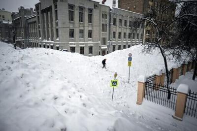
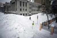
Russia's capital Moscow has this month seen the largest snowfall in more than 200 years, Moscow State University meteorologists said on Thursday.
AFP images from the city of around 13 million people showed residents struggling to make their way through heavy piles of snow on the streets in its central district.
Commuter trains in the Moscow area were delayed, AFP reporters witnessed, and cars were stuck in long traffic jams on Thursday evening.
"January was a cold and unusually snowy month in Moscow," the university said on social media.
"By January 29, the Moscow State University Meteorological Observatory had recorded almost 92 mm of precipitation, which is already the highest value in the last 203 years," it added.
Snow piles on the ground reached as high as 60 centimetres (24 inches) in some parts of the capital on Thursday.
Snow is mostly air, meaning the level of settled snow far surpasses scientific measurements of precipitation -- which measures the amount of water that has fallen.
The record snowfall was "caused by deep and extensive cyclones with sharp atmospheric fronts passing over the Moscow region", the observatory said.
"There was much more (snow) when I was a kid, but now we practically don't have any snow at all, there used to be much more," Pavel, a 35-year-old bartender and Moscow resident, told AFP, grumbling about a feeling of "emptiness" in the dark, snowy winter.
Earlier this month, Russia's far east Kamchatka region declared an emergency situation due to a massive snowstorm that left its major city partially paralysed.
Images, widely circulated online, showed huge snow piles reaching up to the second storey of buildings and people digging their way through roads as snow blanketed cars on either side.
Keep it Clean. Please avoid obscene, vulgar, lewd,
racist or sexually-oriented language. PLEASE TURN OFF YOUR CAPS LOCK. Don't Threaten. Threats of harming another
person will not be tolerated. Be Truthful. Don't knowingly lie about anyone
or anything. Be Nice. No racism, sexism or any sort of -ism
that is degrading to another person. Be Proactive. Use the 'Report' link on
each comment to let us know of abusive posts. Share with Us. We'd love to hear eyewitness
accounts, the history behind an article.
...EXTREME COLD WARNING REMAINS IN EFFECT UNTIL NOON CST SUNDAY...
...WIND ADVISORY REMAINS IN EFFECT UNTIL 9 PM CST SATURDAY...

* WHAT...For the Extreme Cold Warning, dangerously cold wind chills
as low as 3 above expected. For the Wind Advisory, northwest winds
15 to 25 mph with gusts up to 40 mph expected.

* WHERE...Autauga, Bibb, Blount, Chilton, Dallas, Etowah, Fayette,
Greene, Hale, Jefferson, Lamar, Lowndes, Marengo, Marion, Perry,
Pickens, Shelby, St. Clair, Sumter, Tuscaloosa, Walker, and
Winston Counties.

* WHEN...For the Extreme Cold Warning, until noon CST Sunday. For
the Wind Advisory, until 9 PM CST Saturday.

* IMPACTS...Gusty winds will blow around unsecured objects. Trees
could be blown down and a few power outages may result. Frostbite
and hypothermia will occur if unprotected skin is exposed to these
temperatures. An extended period of subfreezing temperatures could
cause pipes to burst.

PRECAUTIONARY/PREPAREDNESS ACTIONS...

Winds this strong can make driving difficult, especially for high
profile vehicles. Use extra caution.

Secure outdoor objects.

Dress in layers including a hat, face mask, and gloves if you must
go outside.

Keep pets indoors as much as possible.

Make frequent checks on older family, friends, and neighbors. Ensure
portable heaters are used correctly. Do not use generators or grills
inside.

To prevent freezing and possible bursting of pipes they should be
wrapped, drained, or allowed to drip slowly.

&&
Currently in Selma
27°
28° / 26°
12 PM
28°
1 PM
29°
2 PM
30°
3 PM
31°
4 PM
31°
Get Black Belt News headlines for free in your inbox every day!
Success! An email has been sent to with a link to confirm list signup.
Error! There was an error processing your request.


(0) comments
Welcome to the discussion.
Log In
Keep it Clean. Please avoid obscene, vulgar, lewd, racist or sexually-oriented language.
PLEASE TURN OFF YOUR CAPS LOCK.
Don't Threaten. Threats of harming another person will not be tolerated.
Be Truthful. Don't knowingly lie about anyone or anything.
Be Nice. No racism, sexism or any sort of -ism that is degrading to another person.
Be Proactive. Use the 'Report' link on each comment to let us know of abusive posts.
Share with Us. We'd love to hear eyewitness accounts, the history behind an article.