
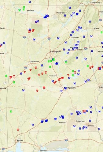
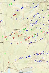

The National Weather Service released confirmations of tornadoes that hit Alabama on Jan. 12, including several in the Black Belt.
Selma's tornado is listed as the sixth twister that hit the state on Thursday as part of "supercell thunderstorms that spawned significant tornadoes that caused paths of damage over several areas. Some damage paths contain significant damage. Thunderstorms also produced damaging straight-line winds over many areas, as well as hail up to golf ball size."
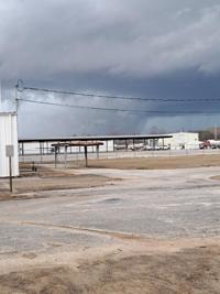
NWS confirms Selma's was a "high-end" EF2 tornado that started east of Orrville.
Here is the report on Selma's tornado:
"National Weather Surveys have concluded that the damage across Dallas County was consistent with a high-end EF-2 tornado. The tornado began just east of Orrville near the intersection of Hwy 22 and Cahaba Rd. As it moved northeast, it intensified as the damage path was nearly parallel with Hwy 22. The damage consisted of mainly uprooted trees with trunks that were snapped. There were also several manufactured homes that sustained roof and some foundation damage. As the tornado continued down Hwy 22, additional tree damage was observed as it neared the southwestern sections of Selma. The tornado quickly intensified as it entered the city limits of Selma, nearly parallel to Hwy 22/W Dallas Ave. the main damage indicators used were the uprooted hardwood trees and the snapped softwood trees. Most of the softwood trees were snapped about halfway up on the trunks. The daycare on W Dallas Ave and Cooper Dr sustained heavy exterior wall damage and was consistent with the higher-end EF2 wind speeds. Some debris rowing was also noted in the downstream vicinity. The second area of higher-end EF2 damage was noted downstream at the Selma Country Club where buildings had significant roof and exterior wall damage and there was a complete blow down of extremely large hardwood trees. Additional softwood trees were also snapped in and around adjacent streets. As the tornado continued further north and east, it entered the northern sections of downtown Selma. Nearly all of the damage continued to consist of mainly trees, with hard and softwood trees uprooted. The homes that sustained damage were observed to have roof material missing or fallen trees that impacted the structure. Very little damage observed to homes was directly wind related likely due to the sheltering nature of the very large and older trees that were embedded within the historic neighborhoods. However, the tree fall damage remained consistent with high-end EF-1 or low-end EF-2. As the tornado exited downtown, it crossed Hwy 14, east of Selma, crossing Parkway Dr. Additional structure damage was noted with exterior walls were collapsed consistent once again with higher EF-2 wind speeds. The tornado finally began to weaken and lift just east near the Brantley community near River Rd, but not before some significant damage was observed at the Dallas County Jail on Selfield Rd."
NWS says they will continue surveys and in the coming days, additional UAS and aerial imagery will be analyzed as numerous roads in the Selma area were inaccessible. This could result in changes to the path length, width and/or EF rating.
As for the other tornadoes in the Black Belt, the NWS confirmed an EF2 tornado hit Sumter County near Emelle and an EF1 tornado hit Greene County near Eutaw and are continuing to survey to see if the tornado continued into Hale, Tuscaloosa and Bibb counties and whether they were one continuous path or separate tornadoes. NWS also confirms an EF2 tornado hit Hale and Perry counties, with the most notable damage near Greensboro. An EF1 tornado has been confirmed in Perry and Bibb counties that was a separate tornado path downstream from the Greensboro tornado.
Survey efforts will continue across many areas in Central Alabama on Saturday. Areas include Hale, Tuscaloosa, Bibb, Autauga, Elmore, Tallapoosa, Coosa, and Chambers Counties. Any results or information from those surveys will be shared as it becomes available. These survey efforts will continue beyond Saturday.
(0) comments
Welcome to the discussion.
Log In
Keep it Clean. Please avoid obscene, vulgar, lewd, racist or sexually-oriented language.
PLEASE TURN OFF YOUR CAPS LOCK.
Don't Threaten. Threats of harming another person will not be tolerated.
Be Truthful. Don't knowingly lie about anyone or anything.
Be Nice. No racism, sexism or any sort of -ism that is degrading to another person.
Be Proactive. Use the 'Report' link on each comment to let us know of abusive posts.
Share with Us. We'd love to hear eyewitness accounts, the history behind an article.